Hatchett Family Maps
Chesterfield Land Patents
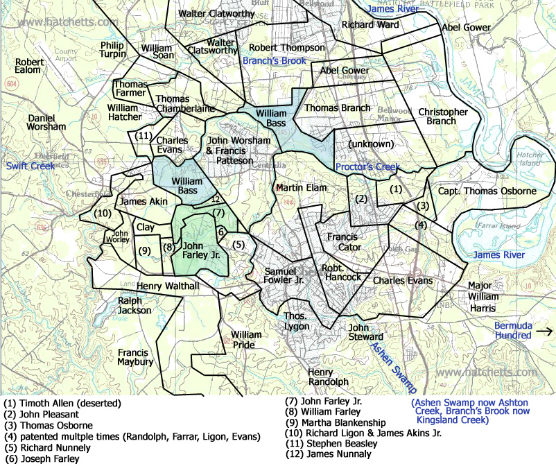
The map below shows the land patents for the area of Chesterfield County between Bermuda Hundred (the mouth of the Appomattox River) and Richmond along the south bank of the James River. Originally this was in Henrico County, but was later split off as Chesterfield County. This shows the neighborhood where John Hatchett probably lived as an indentured servant to John Farley in the late 1600's. John Hatchett was indentured at the age of 10 and served John Farley until his early 20's. Family history relates that John married Elizabeth Bass, possibly the daughter of William Bass. John Hatchett patented his own land on Third Branch of Swift Creek, about 8 miles east of Farley's land. I am working on the same type of map showing the location of that property, and will add it to this website. See my notes below the map for more information on early land patents.

Early Virginia land patents such as those on the map above are sometimes tricky to figure out. Most of the properties were described using "metes and bounds", referring to landmarks having little value today ("corner pine", "scarred pohickory", "field where an old oven stood", etc.). This can make piecing together the locations of the properties on today's maps difficult. Adding to this is the occasional error in the recorded property description. The locations on the map above should viewed as approximate depictions of the properties and their locations.
The date of record for these old patents must be taken with a grain of salt. Evidently it was common for these original landholders to delay officially recording their land for years. So determining who was living on a particular parcel at a particular time can be difficult until additional transactions are recorded as the property is bought and sold or passed through probate. Sometimes a particular area was patented multiple times. The original owner may have deserted the claim, or failed to fulfill their minimum requirements.
Patent map created with the help of DeedMapper